The Mixed Reality Forums here are no longer being used or maintained.
There are a few other places we would like to direct you to for support, both from Microsoft and from the community.
The first way we want to connect with you is our mixed reality developer program, which you can sign up for at https://aka.ms/IWantMR.
For technical questions, please use Stack Overflow, and tag your questions using either hololens or windows-mixed-reality.
If you want to join in discussions, please do so in the HoloDevelopers Slack, which you can join by going to https://aka.ms/holodevelopers, or in our Microsoft Tech Communities forums at https://techcommunity.microsoft.com/t5/mixed-reality/ct-p/MicrosoftMixedReality.
And always feel free to hit us up on Twitter @MxdRealityDev.
More than 1200 triangles per qubic meter

We have created a app which use the special mapping and compare the quality of scan with 200tpqm and 1200tpqm. The standard is 500.
It looks like a the certain point the quality of mesh is not improving. 1200 seems to be the limit.
See the app in action:
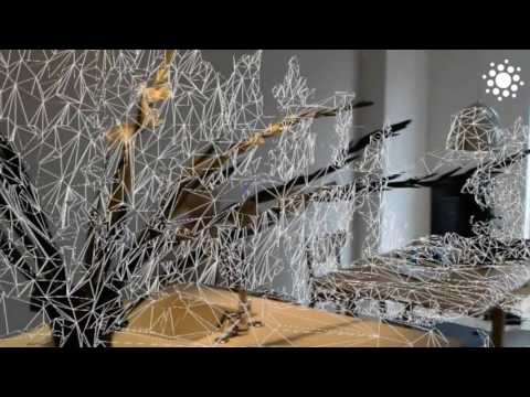 https://www.youtube.com/watch?v=kgCltzwW8i4
Any idea?
Best Answer
-
Options
 ahillier
mod
ahillier
mod
Hi @Marek,
Spatial Mapping LODs don't really map to exact values, but fall within ranges (high, med, low). If you specify a value below the min supported triangle count, then the min will be used. If you specify a value above the max supported triangle count, then the max will be used. The Spatial Mapping components in Unity, offer three LOD levels, which currently use the following triangle counts:
Low -> 100
Med -> 750
High -> 2000In our Spatial Mapping 230 course, we use 500 for med, and 1200 for high. If you don't see any difference between 1200 and 2000, then it is likely that you are already within the high range (max). LOD can also be affected by how detailed the scanning objects are (those plants are pretty detailed, so you should be able to see differences at each LOD). You might not see much of a difference when viewing large, flat surfaces like walls and floors. You will also get the best scanning experience when standing closer to the object (but no closer than 0.8 meters).
I believe that the Spatial Mapping team is planning to expose the LOD via an API, to make it easier for developers to choose (so you don't have to guess at values and so that you can know the error associated with each LOD), but there is no set release date for this API, so it could be a while. If something like this would prove helpful to you, or you need a higher LOD than what you can get today, I suggest opening a bug in the feedback hub. This will help prioritize work for the team.
Thanks!
7
Answers
Hi @Marek,
Spatial Mapping LODs don't really map to exact values, but fall within ranges (high, med, low). If you specify a value below the min supported triangle count, then the min will be used. If you specify a value above the max supported triangle count, then the max will be used. The Spatial Mapping components in Unity, offer three LOD levels, which currently use the following triangle counts:
Low -> 100
Med -> 750
High -> 2000
In our Spatial Mapping 230 course, we use 500 for med, and 1200 for high. If you don't see any difference between 1200 and 2000, then it is likely that you are already within the high range (max). LOD can also be affected by how detailed the scanning objects are (those plants are pretty detailed, so you should be able to see differences at each LOD). You might not see much of a difference when viewing large, flat surfaces like walls and floors. You will also get the best scanning experience when standing closer to the object (but no closer than 0.8 meters).
I believe that the Spatial Mapping team is planning to expose the LOD via an API, to make it easier for developers to choose (so you don't have to guess at values and so that you can know the error associated with each LOD), but there is no set release date for this API, so it could be a while. If something like this would prove helpful to you, or you need a higher LOD than what you can get today, I suggest opening a bug in the feedback hub. This will help prioritize work for the team.
Thanks!
Hi Angela,
Thank you for the response, this would be good to know in the documentation, because in the DirectX/C++ example it alludes to the fact that these numbers represent how many vertices you can build per cubic meter, not a range. I spent some time wrestling with this myself. Now that you explain it this way this does align with how the sample works. I do notice about 3 basic levels of detail on complex surfaces.
Dwight Goins
CAO & Founder| Independent Architect | Trainer and Consultant | Sr. Enterprise Architect
MVP | MCT | MCSD | MCPD | SharePoint TS | MS Virtual TS |Windows 8 App Store Developer | Linux Gentoo Geek | Raspberry Pi Owner | Micro .Net Developer | Kinect For Windows Device Developer
http://dgoins.wordpress.com
Hello, any improvements in terms of scanning LOD of the mesh? Is the 2000 still maximum value?